Location research

Dholera Outside SIR Plots: A 16-Village Location and Road-Distance Guide

By Rahul Jain · Last updated:

A plot is advertised as “near Dholera SIR”. The rate is a fraction of what you have seen inside the SIR. The brochure mentions the airport and the expressway, and the salesperson says development is coming this way. Before you pay a token amount, three questions decide whether that description means anything. Where exactly is the plot? How far is it by road, not on a map? And what is the land legally allowed to be?

Dholera outside SIR plots are not a single product. Two villages that both sit “outside the SIR” can differ by 20 km of road, by district, and by whether a planning authority has any say over them at all. This guide covers 16 villages that are commonly marketed this way. For each one it gives what is known about its location, what has been measured, and what still has to be checked before you pay.

Our approach is to investigate the actual plot location, available road connectivity, applicable planning references and relevant property records before drawing conclusions. This page applies that approach at village level. It cannot do it for your specific plot. Only your survey number can do that.

How to read the figures on this page

Source-reported means a figure from a third-party guide (dholerasmartcityinfo.com, 11 Oct 2026) that we have not checked.

Measured means a DholeraGIS road route we ran on 13 October 2026 from a village’s mapped centre point. Neither is a distance from your plot, and neither is a distance to the SIR boundary.

What are Dholera outside SIR plots?

Dholera outside SIR plots are land parcels near the Dholera Special Investment Region (SIR) that fall outside its notified boundary. That means the Dholera Special Investment Regional Development Authority (DSIRDA) does not plan them, no town planning (TP) scheme covers them, and they get no final plot (FP) number.

The Dholera SIR is a notified area of about 920 sq km. Inside it, land is developed through TP schemes under a sanctioned development plan: roads are reserved, land is pooled, and each owner eventually receives a demarcated final plot. Outside it, land stays ordinary revenue land. Your title, permitted use and road access depend on the parcel’s own records and permissions, not on the SIR plan.

So proximity to Dholera tells you very little on its own. Three things have to be checked separately:

  • Location: the exact parcel, by survey number, and where it actually sits.
  • Access: whether there is a legal, usable road to it, and how long the real route is.
  • Legal status: ownership, land-use classification, non-agricultural (NA) status where relevant, and any permission for plotting.

A plot can pass one of these and fail the other two. For the full comparison, see inside vs outside Dholera SIR.

Why “near Dholera” can be misleading

Distance claims in Dholera marketing usually mean one of five different things, and sellers rarely say which.

Five kinds of distance claim and what each tells a buyer
What is being measuredWhat it tells youWhat it hides
Straight-line distanceHow far apart two points are on a mapRivers, creeks, salt pans and missing roads
Road distanceHow far you actually driveWhether the road is paved, public or passable in monsoon
Travel timeHow long the drive takes at typical speedsTraffic and road condition on the day
Distance to the SIR boundaryHow close the land is to the planned areaThe boundary edge may be undeveloped farmland
Distance to a usable entrance or facilityWhether you can reach something that existsNothing, which is why it is the one to ask for

Here is a measured example. Kamatalav’s village centre is 5.4 km from Dholera International Airport in a straight line, but 17.8 km by road, more than three times as far, because no direct road crosses the land between them. A plot “5 km from the airport” there would be honest as a map measurement and misleading as a description of access.

How to verify a plot location with DholeraGIS

DholeraGIS is our free browser tool. You paste a Google Maps location (or enter coordinates), and it calculates road distance and estimated driving time to 16 Dholera reference points, including Dholera SIR Core, the ABCD Building / Activation Area and Dholera International Airport. It uses OpenStreetMap road data through the OSRM routing engine, and it works on a phone with nothing to install.

To check a shortlisted plot, record the following before you discuss price:

  1. The exact project entrance. Drop a pin at the gate or the plot itself, not at the village. Ask the seller to share the location from the site.
  2. The village and survey number, in writing.
  3. The destination you care about, for example the SIR core, the airport or the Activation Area.
  4. Straight-line and road distance side by side. A large gap means the route detours.
  5. The date you measured. Road data changes as roads are mapped and built.
  6. Route limitations. Look at the route on the map. Does it use a village track, a canal bank or a private road?
  7. What you saw on site, if you visit: road surface, approach width, drainage, boundary markers.

DholeraGIS tells you where a point is and how far it is by road. It does not tell you who owns the land, whether it is inside the SIR, what it may be used for, or whether plotting is permitted. Those come from records, covered in the checklist below.

Check a location in DholeraGIS

Dholera SIR map: 16 outside-SIR villages and where they sit

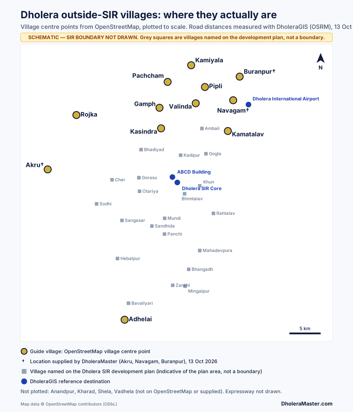
Schematic map of villages around Dholera SIR plotted at their real coordinates: Pachcham, Kamiyala, Pipli, Valinda, Gamph and Kasindra to the north, Buranpur, Navagam and Kamatalav near the airport, Rojka and Akru to the west and Adhelai to the south.
Schematic, plotted to scale from OpenStreetMap village centre points. Grey squares are villages named on the Dholera SIR development plan; they indicate the plan area but are not its boundary, which is not drawn. Four villages in this guide (Anandpur, Kharad, Shela and Vadhela) are not mapped on OpenStreetMap and are not plotted. Akru, Navagam and Buranpur are plotted from locations supplied by DholeraMaster. Map data © OpenStreetMap contributors. Open the full-size map.

The map shows a pattern the village names alone hide. Seven of the villages in this guide (Pachcham, Kamiyala, Pipli, Valinda, Gamph, Kasindra and the airport-side Navagam) sit north of the development-plan villages or level with their northern edge, towards the airport and the Pipli–Fedra road. Buranpur is further north-east, beyond the airport, and Kamatalav is north-east, close to the airport. Rojka and Akru are well to the west, and Adhelai is at the southern end, beyond Bavaliyari.

The 16 villages covered in this guide

These are 16 villages commonly marketed for plots outside Dholera SIR. The list is not exhaustive: other villages around the SIR are sold the same way.

  1. 1. Pachcham
  2. 2. Anandpur
  3. 3. Buranpur
  4. 4. Kamiyala
  5. 5. Akru
  6. 6. Rojka
  7. 7. Kharad
  8. 8. Adhelai
  9. 9. Kamatalav
  10. 10. Kasindra
  11. 11. Gamph
  12. 12. Shela
  13. 13. Valinda
  14. 14. Pipli
  15. 15. Navagam
  16. 16. Vadhela

The source guide we started from refers to both “16” and “17” villages, because its numbering skips from 15 to 17. This guide covers exactly the 16 names above.

Measured road distances (13 October 2026)

Measured with DholeraGIS (OSRM, OpenStreetMap road data) from each village’s mapped centre point. These are not distances from any plot, and not distances to the SIR boundary. A plot at the edge of a village can be several kilometres different.

Measured road distance, straight-line distance and drive time from each village to the Dholera SIR core and to Dholera International Airport
VillageDirection from SIR coreTo SIR core: road (straight)DriveTo airport: road (straight)Drive
KasindraNorth10.3 km (9.1)13 min19.9 km (14.5)33 min
GamphNorth13.9 km (12.3)19 min20.0 km (14.2)36 min
KamatalavNorth-east14.3 km (11.6)14 min17.8 km (5.4)29 min
ValindaNorth15.4 km (13.1)13 min10.1 km (8.4)21 min
PipliNorth17.2 km (16.0)13 min9.0 km (7.5)19 min
RojkaNorth-west20.0 km (19.4)19 min42.9 km (27.5)48 min
Navagam (airport side)†North-east21.4 km (16.0)25 min3.4 km (2.5)8 min
KamiyalaNorth21.6 km (19.0)17 min13.4 km (11.1)24 min
PachchamNorth23.5 km (16.2)23 min15.3 km (13.4)29 min
AdhelaiSouth24.7 km (23.6)17 min47.6 km (39.9)45 min
Buranpur†North-east25.4 km (19.7)21 min17.3 km (4.7)27 min
Akru†West27.7 km (20.8)38 min50.5 km (33.7)67 min
Anandpur, Kharad, Shela, VadhelaNot mapped on OpenStreetMap; not measured

† Measured from a location supplied by DholeraMaster on 13 October 2026, not from an OpenStreetMap village point. Buranpur’s location is about 1 km from the nearest road mapped on OpenStreetMap, so the first kilometre of any route there is not included. Drive times are routing estimates at typical speeds, with no live traffic, and distances may change as road data changes.

Village-by-village research

Each section separates what is reported, what we measured, and what you still need to check. Where we have nothing verified, we say so.

1. Pachcham Village

Reported (source):
About 14 km from the SIR boundary. The source notes limited infrastructure and limited end-user demand.
Measured:
OpenStreetMap places Pachham (its spelling) in Dholera taluka, north of the SIR core: 23.5 km by road to the core (16.2 km straight) and 15.3 km by road to the airport.
The catch:
This Pachham is only about 4 km north of Gamph, which the same source puts 3 km from the boundary. Both figures cannot describe the same boundary and the same village, so confirm which Pachcham a seller means, by taluka and survey number.
Questions to ask:
Which road reaches the plot from the Pipli–Fedra road? Is that road public and paved all the way?
Takeaway:
A long-distance, low-infrastructure location by every measure we have. Price it as a long hold on connectivity, not on SIR development.

2. Anandpur Village

Reported (source):
About 13 km from the SIR boundary, near the Bhogavo river. The source flags waterlogging or flood risk.
Measured:
Nothing. Anandpur is not mapped on OpenStreetMap, and "Anandpur" is a common village name in Gujarat.
Questions to ask:
Which taluka? How close is the parcel to the river and its flood channels? Did the land flood in the last monsoon? Ask neighbours, not only the seller.
Takeaway:
The only firm information is a flood concern. Treat river proximity as the first question, before price.

3. Buranpur Village

Reported (source):
About 14 km from the SIR boundary. Infrastructure and residential demand are described as unclear.
Measured:
From a location supplied by DholeraMaster, Buranpur is north-east of the SIR core, beyond the airport. It is 4.7 km from the airport in a straight line but 17.3 km by road, and 25.4 km by road to the SIR core. The location is about 1 km from the nearest road mapped on OpenStreetMap, so the real approach is longer and its condition is unknown.
Questions to ask:
Which road reaches the plot, and is it public and paved for that last kilometre? Which taluka and survey number? Has any plotted project there completed internal roads?
Takeaway:
Close to the airport on the map, not by road. The approach road is the first thing to see in person.

4. Kamiyala Village

Reported (source):
Near the Pipli–Fedra road. The source warns that plots "behind the village" depend on internal roads rather than touching the highway.
Measured:
OpenStreetMap places Kamiyala in Dholera taluka, at the northern end of this guide: 21.6 km by road to the SIR core and 13.4 km to the airport.
Questions to ask:
Does your plot touch the highway, or is it behind the village? If behind, who owns the internal road, and is it recorded as a right of way?
Takeaway:
"On the highway" and "behind the village" are different products under the same village name. Get the plot's own access confirmed.

5. Akru Village

Reported (source):
"Dhandhuka-side", with projects near land described as green zone.
Measured:
From a location supplied by DholeraMaster, Akru is due west of the SIR core and the furthest west of the villages in this guide: 27.7 km by road to the core (20.8 km straight, about 38 minutes) and 50.5 km to the airport. The nearest village named on the development plan, Sodhi, is about 10 km away.
Questions to ask:
Ask the seller for a location pin taken at the plot. Is the survey number inside or outside the notified boundary? What does the green-zone description refer to, and which document says so?
Takeaway:
A long way from the SIR core and the airport by road. Judge an Akru plot on its own access and records, not on proximity to Dholera.

6. Rojka Village

Reported (source):
Dhandhuka-side, near a green-zone boundary.
Measured:
OpenStreetMap places Rojka in Dhandhuka taluka, well west of the SIR: 20.0 km by road to the SIR core but 42.9 km to the airport. The straight line to the airport is 27.5 km, so the route detours substantially.
Questions to ask:
Which document establishes the green-zone boundary nearby, and does it affect this parcel's permitted use?
Takeaway:
Reasonably connected to the SIR core, far from the airport by road. Check any "airport-side" pitch for Rojka against the route.

7. Kharad Village

Reported (source):
Dhandhuka-side. Nothing else.
Measured:
Nothing; not mapped on OpenStreetMap.
Questions to ask:
Which taluka and survey number? Can the seller share a location pin taken at the plot?
Takeaway:
No location evidence at village level. Start with the survey number and a pinned location from the seller, then measure it yourself in DholeraGIS.

8. Adhelai Village

Reported (source):
On the "Phase 3 / TP6 side" of the wider planning area, with connectivity compared with Phase 1 unclear.
Measured:
OpenStreetMap places Adhelai at the southern end, beyond Bavaliyari, and in Bhavnagar taluka, Bhavnagar district. It is 24.7 km by road to the SIR core (17 min, consistent with expressway access) and 47.6 km to the airport.
Why the district matters:
Records for a Bhavnagar-district parcel are pulled under Bhavnagar on AnyRoR and registered at a different sub-registrar. Confirm the district on the 7/12 extract itself.
Questions to ask:
Which district is the parcel recorded in? Which expressway interchange serves it, and how far is the plot from it?
Takeaway:
Fast to the SIR core by expressway, far from the airport. Check which district the parcel is recorded in before anything else.

9. Kamatalav Village

Reported (source):
Touching the SIR boundary near the solar-park area; low-lying, with possible waterlogging and proximity to a Coastal Regulation Zone (CRZ) area.
Measured:
OpenStreetMap places Kamatalav north-east of the SIR core. It is 5.4 km from the airport in a straight line but 17.8 km by road, and 14.3 km by road to the SIR core.
Questions to ask:
Is the parcel affected by CRZ? Read what the records say about CRZ in Dholera SIR before relying on any answer. Is the land low-lying, and does it hold water after rain?
Takeaway:
"Next to the airport" on a map, not by road. CRZ and drainage are the decisive checks here, not distance.

10. Kasindra Village

Reported (source):
About 1.5–2 km from the SIR boundary. The source itself says this must be measured from the specific project.
Measured:
OpenStreetMap places Kasindra north of the core, level with the northernmost development-plan villages. It is 10.3 km by road to the SIR core and 9.1 km to the ABCD building.
Questions to ask:
At 1.5–2 km, some parcels may sit very close to the notified boundary. Confirm in writing whether this survey number is inside or outside.
Takeaway:
Among the closest villages in this guide by road. That makes the boundary question more important, not less.

11. Gamph Village

Reported (source):
About 3 km from the SIR boundary. Access runs along a village road and then via Ambli to the TP1 industrial area, not directly into the SIR.
Measured:
13.9 km by road to the SIR core (12.3 km straight) and 20.0 km to the airport.
Questions to ask:
Is the village road to Ambli public and paved? Is it wide enough for what you intend to do with the land?
Takeaway:
"3 km from the boundary" still means a village-road approach. Drive it before you pay.

12. Shela Village

Reported (source):
Lies along the SIR boundary, with SIR land on both sides of parts of the village. Access is towards TP1 and the City Centre routes. Some projects show little beyond boundary markers or boards.
Measured:
Nothing; not mapped on OpenStreetMap.
Why this one is different:
If parts of Shela’s revenue land fall inside the SIR and parts outside, the village name tells you nothing. Only the survey number does. See how to verify inside or outside the SIR.
Questions to ask:
Is this survey number inside or outside the notified boundary, in writing? What has been built beyond boundary markers?
Takeaway:
The highest-priority boundary check in this guide.

13. Valinda Village

Reported (source):
About 2.5 km from the SIR boundary. Projects are reached by village roads, and no completed projects were seen at the locations examined.
Measured:
15.4 km by road to the SIR core and 10.1 km to the airport (8.4 km straight), one of the closer villages to the airport by road.
Questions to ask:
Which village road serves the project? Is anything built beyond boundary markers?
Takeaway:
Closer to the airport than to the SIR core. Judge it on the airport corridor, and on what is actually built.

14. Pipli Village

Reported (source):
About 4 km from the SIR boundary. The Fedra–Pipli road passes through, and some projects have reportedly reached a developed stage.
Measured:
17.2 km by road to the SIR core and 9.0 km to the airport, the shortest airport route among the OpenStreetMap-mapped villages in this guide.
Questions to ask:
"Developed" according to whom? Ask to see completed internal roads, drainage and a plotting permission, not a layout drawing.
Takeaway:
The strongest road-connectivity profile in this guide. That raises prices, so verify the paperwork with the same care.

15. Navagam Village

Reported (source):
Associated with the airport site.
Measured:
From a location supplied by DholeraMaster, which agrees with DholeraGIS's Navagam point to within about 100 m: 3.4 km by road from the airport and 21.4 km from the SIR core.
Two Navagams:
The Dholera SIR development plan names Navagam as a revenue village in TP 1, the Activation Area, alongside Bhimtalav and Sangasar. Those villages lie near the ABCD building, about 16 km from the airport-side Navagam. Ask which Navagam, by taluka and survey number. One may be inside the SIR and the other outside.
Questions to ask:
Is the plot affected by airport height or noise restrictions? Read the airport status page and the guide on “near the airport” claims.
Takeaway:
The name alone does not tell you which planning regime applies.

16. Vadhela Village

Reported (source):
Near the TP 5 boundary, with green-zone designation bordering the location; direct connectivity appears limited.
Measured:
Nothing; not mapped on OpenStreetMap.
Questions to ask:
What does “green zone” refer to here? If it is a development-plan zone, check it on the master plan and the zone guide, and confirm whether this parcel is inside or outside the plan area at all.
Takeaway:
A zone claim near a boundary is exactly the kind of statement to check against the plan, not take from a brochure.

Checking a specific location?

Run it through DholeraGIS, then send us the village and survey number. We will tell you which records and location checks apply.

Inside SIR vs outside SIR: what changes

Neither is automatically better or safer. They carry different risks.

Land inside the notified Dholera SIR compared with land outside it
FactorInside Dholera SIROutside Dholera SIR
Boundary positionWithin the notified SIR areaOutside it, regardless of how close
Planning frameworkSanctioned development plan; TP schemesNo SIR plan; ordinary revenue and district rules
Road accessRoads reserved in the TP scheme; built in phasesDepends on existing village and state roads
InfrastructureCommitted in the plan; delivered in phasesNo SIR commitment
Land-use permissionsFixed by the zone the plan assignsDepends on the parcel's own classification and permissions
Title and documents7/12, TP scheme stage and FP number7/12, NA order and plotting permission where relevant
Development statusVaries by scheme stage (draft, preliminary, sanctioned)Varies by project; often boundary markers only
ResalePlanning certainty supports value; market still thinDepends on corridor demand; often thinner
Area deductionTypically 40–50% surrendered in TP schemesNone

Land due-diligence checklist before paying a token amount

Requirements differ by parcel and by what you intend to do with the land. Treat this as the minimum.

  • Exact parcel: Survey number in writing, plus a pinned location at the plot itself.
  • Ownership and title: Pull the 7/12 and 8-A extracts yourself on AnyRoR, under the correct district and taluka, and confirm that every owner named is selling (how to verify a survey number).
  • Inside or outside the SIR: A written answer for this survey number, not the village (verification guide).
  • TP and FP references, if inside: The scheme number, its stage and the final plot number (draft vs sanctioned TP schemes, all TP scheme maps).
  • Land-use classification: Agricultural or non-agricultural, as recorded.
  • NA status, where relevant: The NA order itself, not a reference to it.
  • Layout and plotting permission: The approved layout for the project, if plots are being sold.
  • Legal access: A recorded right of way to a public road, not just a track the seller uses.
  • Utilities: What exists today (power, water), not what is promised.
  • Drainage and flooding: Visit after rain if you can, and ask neighbours.
  • Environmental restrictions: CRZ applicability near the coast and creeks (CRZ in Dholera SIR).
  • Infrastructure claims: For any road, rail or airport claim, ask for the official source and its date.
  • Independent legal review before any payment: Title check · full 21-point checklist

Frequently asked questions

What are Dholera outside SIR plots?

They are land parcels near the Dholera Special Investment Region that fall outside its notified boundary. They are not planned by DSIRDA, not part of any TP scheme, and get no final plot number. Their permitted use and access depend on the parcel's own records.

Which villages are covered in this Dholera outside-SIR village guide?

Sixteen: Pachcham, Anandpur, Buranpur, Kamiyala, Akru, Rojka, Kharad, Adhelai, Kamatalav, Kasindra, Gamph, Shela, Valinda, Pipli, Navagam and Vadhela. The list is not exhaustive, and for Navagam and Shela the village name alone does not settle which side of the boundary a parcel is on.

How can I check a plot's distance from Dholera SIR?

Pin the plot itself, not the village, and run it through DholeraGIS. That gives the road distance and driving time to the SIR core, the Activation Area and the airport. Distance to the SIR boundary itself needs the official boundary map and the parcel's survey number.

What is the difference between road distance and straight-line distance?

Straight-line distance is measured across the map, while road distance is the route you actually drive. They can differ a lot: Kamatalav is 5.4 km from the airport in a straight line but 17.8 km by road (measured 13 Oct 2026).

Are plots outside Dholera SIR worth buying?

That depends on the parcel, not the category. An outside-SIR plot with clear title, a recorded road and the right permissions is a different proposition from one that has only a village name and a brochure. Whether it suits you depends on your horizon and how much uncertainty you can carry. Check the parcel first.

Does a plot near Dholera Smart City automatically benefit from SIR infrastructure?

No. SIR roads, utilities and planning apply inside the notified boundary. Land outside it benefits only if it has a usable route to that infrastructure, which you can measure, and nothing obliges the authority to extend services to it.

What does a TP scheme mean for a Dholera land buyer?

A town planning scheme is how land inside the SIR is reorganised: owners pool land, part of it (typically 40–50%) is taken for roads and services, and each owner receives a smaller, serviced final plot. Outside the SIR there is no TP scheme and no deduction.

What documents should I verify before buying a Dholera plot?

At minimum, the 7/12 and 8-A extracts under the correct district, written confirmation that the survey number is inside or outside the SIR, and the NA order and layout permission where relevant. For inside-SIR land, add the TP scheme stage and FP number. Have a lawyer review them before you pay.

Can DholeraGIS verify ownership or legal approval?

No. DholeraGIS shows where a point is and measures road distance and driving time. Ownership, title, land use and approvals come only from official records such as the 7/12 extract and the relevant orders.

Does every plot near Dholera Airport offer investment potential?

No. Proximity on a map is not access by road, and land near an airport can carry height or noise restrictions. Measure the road route, check the restrictions, and judge the parcel on its own records.

How should I verify green-zone claims?

Ask which document the claim comes from. If it refers to the SIR development plan, check the zone on the plan for that exact location. If the parcel is outside the SIR, the SIR plan's zones do not apply to it, so ask what does.

When should I investigate CRZ restrictions?

Whenever a parcel is near the coast, a creek or tidal land, as Kamatalav is reported to be. CRZ applicability is decided by the approved coastal zone management maps, not by distance estimates. Check it before paying anything.

Don’t just trust “near Dholera”. Check the actual location.

A village name on a brochure is where a seller’s description starts, not where your research should end. Measure the road route from the plot itself, confirm which side of the SIR boundary the survey number falls on, and read the records.

Shortlisted a plot? Run its location through DholeraGIS, then send us the village, the project’s pinned location and whatever survey details you have. We will tell you which location and document checks apply to that parcel before you pay.

Disclaimer

This guide is general information, not legal or investment advice. Distances marked source-reported come from a third-party article and have not been verified by us. Distances marked measured are routing estimates from village centre points on 13 October 2026, using OpenStreetMap road data. They are not distances from any specific plot or to the SIR boundary, and may change as road data changes. Land status, permitted use and approvals must be confirmed from official records for each parcel.

Sources

Seen a change on the ground?

If a TP scheme, final plot, road alignment, layout or project status on this page has changed, tell us. Send the page, what is different, and any document that shows it: a scheme notification, a revenue record or a dated site photo. If we agree, we correct the page and record it in our corrections log.